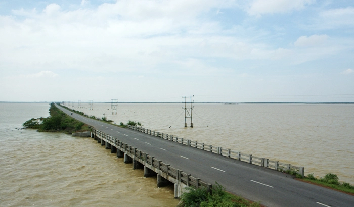
The second largest brackish water lake in India is along the Coromandel Coast, just 990 kilometers from Chennai. Visit here for the bird sanctuary and the exotic barrier island of Sriharikota, which divides the lake from the Bay of Bengal. The island also houses the Satish Dhawan Space Centre and several commercial fisheries.
Pulicat Lake is the second largest brackish waterlagoon in India, (after Chilika Lake), measuring 759 square kilometres (293 sq mi). Major part of the lagoon comes under the Tirupati district of Andhra Pradesh. The lagoon is one of three important wetlands that attracts northeast monsoon rain clouds during the October to December season. The lagoon comprises the following regions: Pulicat Lake (Andhra Pradesh and Tamil Nadu), Marshy/Wetland Land Region (AP), Venadu Reserve Forest (AP), and Pernadu Reserve Forest (AP). The lagoon was cut across in the middle by the Sriharikota Link Road, which divided the water body into lagoon and marshy land. The lagoon encompasses the Pulicat Lake Bird Sanctuary. The barrier island of Sriharikota separates the lagoon from the Bay of Bengal and is home to the Satish Dhawan Space Centre.[1]
In the 1st century, the anonymous mariner who wrote Periplus of the Erythraean Sea listed Podouke (Pulicat)[3] as one of the three ports on the east coast of India. In the 2nd century, Ptolemy‘s list of ports on this coast included Podouke Emporion.[4]
In the 13th century, Arabs migrated to the shores of the lagoon after they were banished from Mecca for refusing to pay tributes to a new caliph. Streets with dilapidated masonry houses once occupied by these Arabian Muslims are still found in the area and resident families claim records in Arabic testifying the migration.[5][6]
Portuguese colonized the lagoon in 16th century followed by the Dutch. The Dutch drifted to the lagoon as their ships got stuck on the shores of Karimanal village on the opposite side of the mouth of the lagoon. During the Dutch occupation, Pulicat was known by the name Pallaicatta.[7] Fort Geldria dating to 1609, a church, a cemetery with tombs and mausoleums constructed by the Dutch are protected by the Archaeological Survey of India (ASI). The Dutch transacted business with the British East India Company and other countries in the region.[5][6][8]
| Pulicat Lake | |
|---|---|
| Palm trees lining the barrier islands | |
| Location | Coromandel Coast, Andhra Pradesh–Tamil Nadu border |
| Coordinates |  13°33′57″N 80°10′29″E 13°33′57″N 80°10′29″E |
| Type | brackish to salty |
| Primary inflows | Arani River, Kalangi River and Swarnamukhi River |
| Primary outflows | Bay of Bengal |
| Basin countries | India |
| Max. length | 60 km (37.3 mi) |
| Max. width | 17.5 km (10.9 mi) |
| Surface area | 250–450 km2 (97–174 sq mi) (from low tide to high tide) |
| Average depth | 1 m (3.3 ft) |
| Max. depth | 10 m (32.8 ft) at the mouth |
| Islands | Irrukam, Venadu and several smaller ones |
| Settlements | Sriharikota Pulicat Dugarājupatnam Sullurpeta |
sneeriest xyandanxvurulmus.2LsFL2rUif0A
I loved you even more than you’ll say here. The picture is nice and your writing is stylish, but you read it quickly. I think you should give it another chance soon. I’ll likely do that again and again if you keep this walk safe.
It was great seeing how much work you put into it. The picture is nice, and your writing style is stylish, but you seem to be worrying that you should be presenting the next article. I’ll almost certainly be back to read more of your work if you take care of this hike.